Red Lake Mining Division · Ontario

Little
Shabumeni
River Project

On the Confederation Trend, 30 miles east of Red Lake and 60 miles north of Ear Falls.

Project at a glance

A strategically accessible grassroots property

52cells
3,120acres
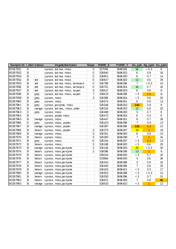
2021Geotech “VTEM plus” airborne survey
2025preliminary soil sample

Property advantages

  • Red Lake Mining Division: on the Confederation Trend: 30 mi. E of Red Lake: 60 mi. N of Ear Falls.
  • Access by all-weather, all-season logging road passing through our claim block. Unrestricted public usage.
  • High-voltage transmission line near at hand within five miles.
  • Clearcut circa 2015. No commercial timber remains within our claim boundaries.
  • No running water within our claim boundaries – ecologically benign.
  • Aboriginal Consultations have been done with due diligence. Excellent rapport is maintained.
  • Secure land tenure to 2027 and beyond.
  • Full VTEM and soil-sample reports available on request.

The original field story

History: the 1969 anomaly

In 1969 I was the NW Ont geophysical foreman for a major Canadian mining firm. Selco had announced development of their South Bay Zn, Cu, Ag mine, kicking off a staking rush. My company responded by flying a fixed-wing airborne survey from South Bay northward along that portion of the Con Trend. At the same time they had picked up a 200 claim option near North Spirit Lake, so with up to 20 men of various disciplines roaming around, I had a busy yet enjoyable summer.

In early Sept with season’s end near and manpower drifting away, I myself took two young lads in to check the last of our anomalies – an orphan on the north western fringe of the airborne survey. We flew in by Beaver and threw up a quick fly camp. We had no radio and had told the air service to give us three good-weather work days with a return flight in the pm of day four. This schedule would give us time to do a competent preliminary ground survey while enabling us to skedaddle before Sept weather locked us in.

The 20-claim block had been staked, cut and chained by Jean Alix of Val D’Or, the go-to people of the day. The line spacing was 400’ with 100’ stations, giving us 20 line-miles to survey.

We used a Crone JEM (Junior Electro-Magnetic) and a McPhar MF-1 fluxgate magnetometer. The JEM was a battery powered, dual-frequency transceiver unit. Used in-line (shoot back), with a coil separation of 200’, it gave us 100’ of depth penetration, considered adequate for a primary survey. As an added feature (unknown and unused by less experienced operators) the JEM could easily be reconfigured to vertical-loop mode – an excellent tool for field interpretation. The McPhar fluxgate was one of the preferred magnetometers of that era.

We had done the usual air recon before setting up camp so I knew we would have no difficult topography to deal with. It was my usual habit to start all field surveys at the furthest point from camp. Thus, if we had a couple of miles to do before our return flight came in, we could complete the survey in early am.

We did the survey in loops with myself as lead hand always on the south. The mag man, a new hire that spring, was proving to be a “keeper” but I still kept him close at hand to monitor his readings in case some detail was indicated.

Day one proved to be uneventful – our readings were as flat as the ground we walked on. The area was treed with mature poplar and jackpine with scant underbrush. We saw no outcrop nor float.

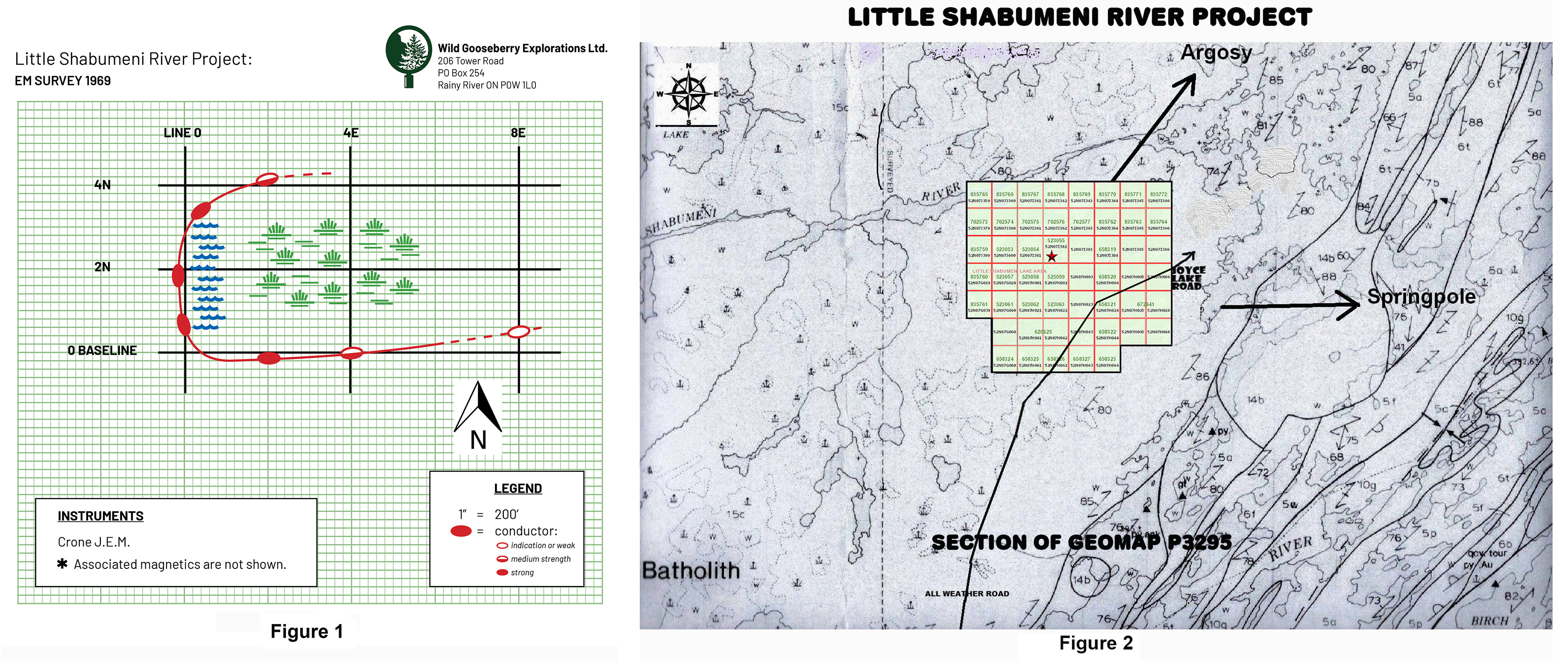
Day two started out likewise – flat, flat. Near noon, coming up what I call line 8E, (see sketch) I picked up an indication. It was only 3 dip-angle degrees but I was always aware of my surroundings. Topo can give you hints and we were at the tip of what appeared to be an open area to our west.

Coming down line 4E we found the open area to be a dry swamp – hardly a depression but within its boundary there were NO trees – only sparse clumps of willows. At the swamp’s southern perimeter we picked up a medium strength conductor with associated mag activity. (Figure three)

Coming up line Zero we hit the swamp at its west end and we were now virtually in the center of our 1969 claim block. Here the conductor was quite strong with a low-to-high frequency ratio of 60%. We also had a medium strength flanking mag high indicating a southerly dip.

We continued northward along the western fringe of the swamp which had ended with a berm of perhaps two feet. To our right were small pools of water and to our left was a fringe of cedars – the only cedar trees we had come across. My EM readings became out-of-phase (noisy) and I had difficulty pinning down a null point. Magnetics were also erratic but after 300 – 400’ the swamp boundary curved eastward and our readings told us that we were leaving the conductive zone.

We reviewed our field notes and it was obvious that we had been following rather than intersecting the conductor. We returned to the south side of the swamp and I switched the JEM to vertical loop mode. With my partner transmitting, I read a series of short E/W lines all at 50’ coil spacing. As I had suspected, the conductor followed the curve of the swamp, folding back eastward. I also proved that the conductor was at a depth of less than 25’ at the fold. The magnetic picture also cleared up, but without proper grid control it was pointless to record the readings.

However, before we moved on, we ran two short compass and pace shoot-back lines – one at 2E and one at 2W. 2E confirmed the fold and 2W confirmed that the zone did NOT extend westward. I would have liked to cut and chain a small detail grid but we lacked the tools and the time. We still had ten line-miles to do and a date with warm beds and hot running water in Red Lake. The rest of the grid replicated the east half – no action.

In Red Lake I tuned up my field maps and wrote a report recommending a small detail grid and a priority one drill target. My superiors demurred with the decision coming from Toronto. “Too expensive!” and even now, many years later, I do not understand why. However – in those days we had a reputation of doing excellent field work with piss-poor drill follow-up.

A reader of this may think the foregoing has been unnecessarily descriptive, however there is a point to this process: In 1969 I was in year ten, geophysically speaking. I had covered the Shield from Contwoyto Lake NWT to Chibougamau PQ, including almost every greenstone belt in Ontario. I had been part of detailed surveys of two future producers but:
Never, ever, had I seen anything as interesting as that folding conductor in a treeless oasis in the center of a broad expanse of glacial till.

Interpretation and field planning

Conclusions and recommendations

Conclusions (1969)

  • I ruled out a water-filled shear zone for obvious reasons: The low-to high frequency ratio would have been as low as 10% and magnetics would be unlikely to occur.
  • I ruled out iron formation/graphite. The EM curve would have been more sharply defined and magnetics would have been higher and more closely aligned.
  • I considered the folding conductor as poly-metallic (massive sulfides). I theorized that a primary intrusion existed beneath the Mainprize Batholith. We were near the eastern fringe of this pluton and perhaps a small portion of the earlier intrusion had been left uncovered by the thinning Mainprize. When glaciated, this tip of the iceberg, being softer than the surrounding grano-diorite, eroded more easily, leaving the ½ acre swamp depression in its wake.
  • The conductor did not extend eastward more than 600 feet. At the time I surmised a plunge and/or heavier overburden.
  • My “massive sulfides” may explain lack of timber in the swamp. Certain sulfides are highly acidic. Poplars (the predominant species) won’t germinate in acidic soil. Why the fringe of cedars? A botanical question.

Remarks and Recommendations

In no particular order

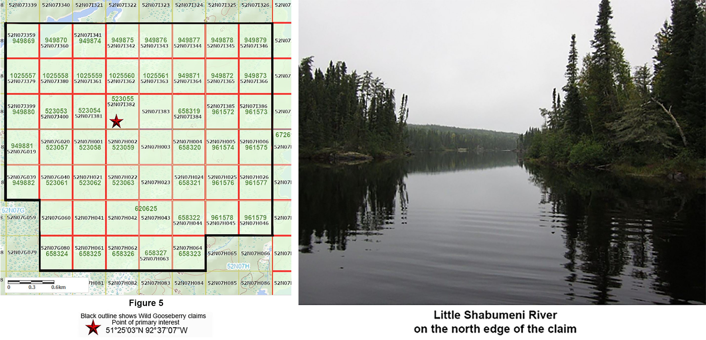
  • With no water or comercial timber within our boundaries, building access roads will be merely pushing deadfall aside. (Figure one)
  • A few short traverses using a Crone Radem or Geonics EM-16 will pinpoint the folding conductor. We saw no boulders in 1969, therefore driving casing to bedrock should be trouble-free. This is a potential preliminary target for a Winkie drill.
  • An alternate exists: a backhoe will easily day-light the bedrock. Eminently economical, this will have the added benefit of allowing one to screen for diamond indicators and/or gold grains.
  • With promising results from early exploration, an expanded program will follow.
  • Our VTEM magnetics are open both easterly and to the south west. At some point a new airborne survey would be advisable.
  • A conventional vertical loop or max-min ground survey would be a waste of time and resources. Induced Potential will fill in the details.
  • The river appears to be a dead zone. I see it as a fault line but is it also a contact separating different blends of the country rock within the batholith? The topography on the north side is a dramatical change compared to our claim block with outcrop ridges that appear to have escaped glaciation.

Modern field evidence

Summary of 2025 soil sampling program and assay results

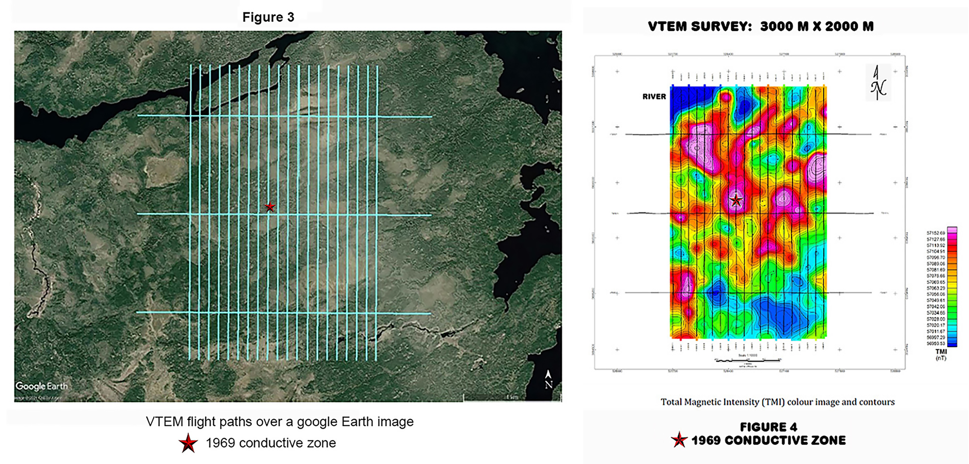
Bob Durnin of Wild Gooseberry Explorations Ltd. (Wild Gooseberry) contracted Bjorkman Prospecting Inc. to carry out reconnaissance soil sampling on their mining claims in the Shabumeni Lake Area, District of Kenora. The claims are located south of Little Shabumeni River and west of Little Shabumeni Lake (see Fig. 1), located 93 km northeast of Red Lake and 95 km north-northeast of Ear Falls, Ontario. The mining claims comprise 48 claims covering 1088.44 Ha (10.88 km²) collectively referred to herein as the Property. Wild Gooseberry is 100% owner of the claims comprising the Property. The Property contains no known mineralization including no Ontario Mineral Inventory records (OMI) or historic drill holes. Only one assessment report has been submitted for the area detailing the results of a VTEM survey commissioned by Wild Gooseberry in 2021.

The purpose of the 2025 soil sampling program was to look for geochemical evidence of mineralization to account for a historic conductive anomaly found while performing a ground EM + magnetic survey in the area in 1969. The EM anomaly was interpreted to follow the curve of a swamp and be ~ 25 feet below surface at one point. Potential economic commodities considered as causing the EM response include base metals, especially massive sulphides associated with a VMS system (Cu-Zn-Pb-Ag) or magmatic Ni-Cu-PGE, and precious metals, especially orogenic gold.

The Property was accessed by driving northeast of Ear Falls, initially on active logging roads, but eventually on an old grown in logging road to within 1.5 km of the property boundary. From thence the property was accessed by foot (Fig. 2). Soil sampling was carried out by a team of two people led by Stuart MacLean over one field day from October 8th, 2025, with two additional mob-demob days (October 7th and 9th; see daily log by MacLean, 2025). Thirty-three samples were collected, described and photographed, typically of the B horizon, but in places of the C horizon or mixed horizons (see notes; e.g., Fig 3). The dried samples were analyzed by Activation Laboratories for gold by fire assay and for trace and major elements using a multielement ICP package.

The Property is underlain by an intrusive complex of the Mainprize Batholith, with the Birch – Uchi Greenstone Belt located 1.7 km to the southeast of the Property and wrapping around to the northeast (Fig. 1). Geological mapping has been carried out by multiple OGS campaigns in the area, but mapping points covering the Property are scant to absent, best represented in the P3295 map by Stone and Crawford (1992; Fig. 1). The Historic Soldor Gold mine, located 14 km south-southeast of the Property, is the nearest past producer, but there are multiple gold and base metal showings to the south of the Property within the Birch-Uchi Greenstone Belt. There are gold and silver showings within the Mainprize batholith near its southern margin, about 15 km to the southwest of the Property (Stone and Crawford, 1992), which is a similar geologic environment to the Property.

Results from the October 2025 exploration (Table 1 and Figures 3-6) includes anomalous gold values in two locations (142, 132 ppb). Many of the samples have anomalous silver based on a threshold of Ag>0.5 g/t (1-1.1 g/t, n=7, 0.6-0.9 g/t, n=20). The highest gold-bearing samples are ~150 m apart; one sample is described as “orange” B horizon with a likely bedrock parent, while the other is “grey” B horizon, with a possible till parent. The highest copper value is 50 ppm; the highest zinc is 84 ppm, with five samples having >70 ppm Zn, the highest nickel value is 41 ppm. These base metal values in the soils fall within common ranges defined for soils, below thresholds for anomalous values, and therefore do not indicate the presence of base metal mineralization. No standards or blanks were analyzed.

A practical exploration path

Recommendations for future work

These gold – silver results warrant further exploration. The following steps are recommended:

  1. Improve access.Make a new trail into the Property. Figure 2 shows the location of a proposed trail, but this should be walked as well as other potential routes, before making a trail.
  2. Field visit anomalies.The new Au in soil anomalous areas should be field visited with the intention of mapping and prospecting.
  3. Additional soil sampling.Complete sampling at a larger scope over the Property (e.g., 25 m interval 100 m line spacing), as well as in detail (10 m interval) near the anomalies. This will help define background values for the area and pinpoint the source of gold, whether bedrock or till.
  4. Till sampling.A till sampling program could also be undertaken.
  5. Ground IP survey.A ground IP survey, which can pick up disseminated sulphides, should also be completed over the Property, especially over areas with anomalous gold. For this, a grid would need to be cut.
  6. Mechanical stripping.Expose bedrock in areas with anomalous gold values where possible. Geological mapping and channel sampling should be undertaken on the stripped areas where warranted.
  7. Drill the best targets.The final recommendation is to drill the best targets.

Profiles of principals

The Wild Gooseberry team

Robert (Bob) Durnin

President & CEO

Bob Durnin is a veteran prospector with more than a decade of active exploration experience during the mid-20th century and a lifelong interest in mineral exploration. An old-school field man, Bob developed his skills through direct observation, practical experience, and countless hours on the ground rather than through modern software and technical modeling.

Howard G Hampton

BA, B ed, LLB (MLA 24 yrs)

VP legal and Aboriginal Affairs
Partner in Pilot Law
Strategic Advisor and Investor

Howard Hampton is a lawyer, former Leader of the Ontario New Democratic Party, and former Ontario Minister of Natural Resources. Throughout his public and professional career he has been closely involved with natural-resource policy, northern development, land-use planning, and issues affecting Ontario's mining and resource sectors.

Kat Bjorkman Phd, P.Geo

Advisor
Consultant - Field Sampling and Exploration Support

Harold McQuaker

Advisor

Owner of Harold McQuaker Enterprises for over 50 years as a heavy equipment contractor.

Margaret J. Durnin

VP and CFO/Treasurer

Franklin Newhart

Secretary and Profile Administrator

Franklin Newhart is an Ontario-licensed prospector with a long-standing interest in mineral exploration, mining history, and resource development. He has participated in prospecting activities in Ontario and contributes field research, project documentation, historical property investigation, and public communications for Wild Gooseberry Explorations Ltd.

Mr. Newhart's background includes manufacturing, engineering support, technical documentation, and graphic design. He is responsible for maintaining company profile materials and assisting with the presentation of exploration projects to investors and the public.

Current Roles:
• Company Prospector
• Project Research and Documentation
• Historical Property Investigation
• Profile and Website Administration

Further information

Contact Mr. Newhart

Wild Gooseberry Explorations Ltd.

206 Tower Road
PO Box 254
Rainy River ON P0W 1L0
Download provided document